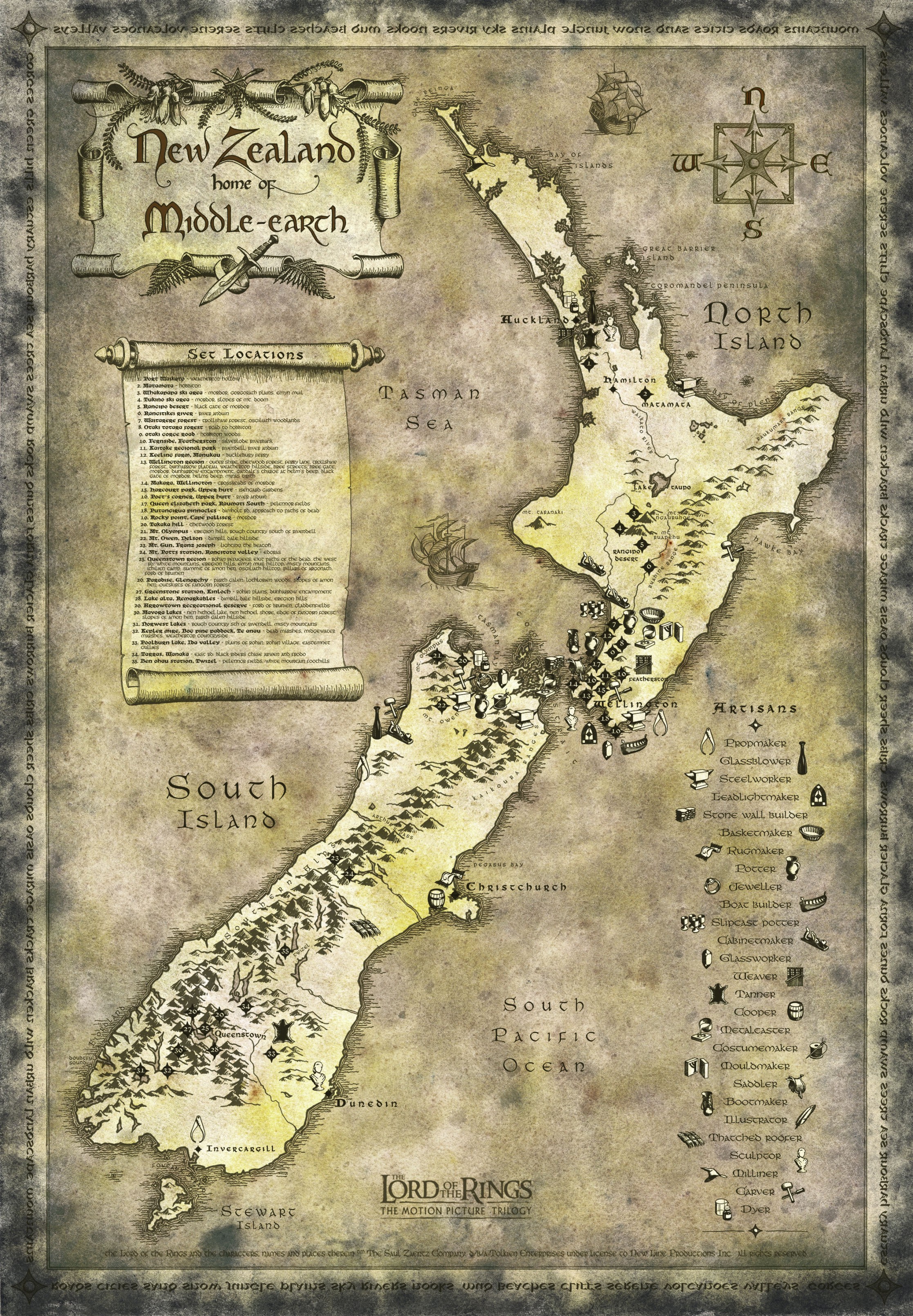
La trilogie du Seigneur des Anneaux (LOTR pour les anglophones), tournée en Nouvelle Zélande, est devenue l'un des ressorts touristiques les plus importants du pays.
Puisque le sujet ne semble pas avoir été abordé plus avant, je vous propose cette liste trouvée sur le (génial et importantissime) site du
Department of Conservation et qui répertorie, je cite:
Below is a tour of the New Zealand conservation areas that provided locations for Peter Jackson's Lord of the Rings trilogy:
La page source:
Lord of the Rings locations tour: Places to visit
Note on GPS coordinates: These are guidelines only. They based on estimates from DOC staff and coordinates from
The Lord of the Rings Location Guide Extended Edition by Ian Brodie (HarperCollins, ISBN 1-86950-530-1).
The
New Zealand Road Spiral Atlas (HEMA, ISBN13 9781877302367) features Lord of the Rings locations.
Tongariro/Taupo region Ithilien Mangawhero River Gollum catches a fish.
Ohakune area short walks
Tongariro National Park
Coordinates: 39° 19.161'S 175° 30.158'E - view in
Google maps
Access: Ohakune Mountain Rd
Mordor Mangawhero River Frodo and Sam pass a ruined column in a clearing.
Ohakune area short walks
Tongariro National Park
Coordinates: 39° 19.217'S 175° 30.315'E - view in
Google maps
Access: Ohakune Mountain Rd
Mordor Whakapapa skifield Isildur cuts off Sauron's finger and the Ring.
Tongariro National Park
Coordinates:
- View of location: 39° 14.116'S 175° 33.529'E - view in Google maps
- Location: 39° 14.114'S 175° 33.522'E - view in Google maps
Access: State Highway 48
Mordor Whakapapa skifield Frodo and Sam catch Gollum. Gollum leads the hobbits down the Emyn Muil.
Tongariro National Park
Coordinates: 39° 14.177'S 175° 33.670'E - view in
Google maps
Access: State Highway 48
Gates of Mordor Tukino skifield, Mt Ruapehu Frodo, Sam and Gollum look out over the Gates of Mordor before setting out to climb around them.
Tongariro National Park
Coordinates: 39° 16.667'S 175° 36.626'E - view in
Google maps
Access: Walk in from gate on Tukino skifield road, off SH1
back to top Wellington region Dimholt Road Putangirua Pinnacles Aragorn, Legolas and Gimli ride to meet the Army of the Dead.
Pinnacles track
Putangirua Pinnacles, Aorangi Forest Park
Coordinates: 41° 26.861'S 175° 14.674'E - view in
Google maps
Access: Walk-in access from Whatarangi Rd
Nelson/Marlborough region Dimrill Dale Mount Owen The Fellowship, now without Gandalf, escape Moria.
Mount Owen route
Kahurangi National Park
Coordinates: 41° 33.493'S 172° 32.401'E - view in
Google maps
Access: Challenging walk-in only
Outcrop south of Rivendell Mount Olympus/Boulder Lake The Fellowship hide from the crebain, Saruman's black crows.
Kahurangi National Park
Coordinates: 40° 53.456'S 172° 30.654'E - view in
Google maps
Access: Challenging walk-in only (unmarked)
West Coast region Ered Nimrais Mount Gunn, near Franz Josef Glacier The beacons that run along The White Mountains from Gondor to Rohan are lit.
Franz Josef Glacier
Coordinates for view of Mt Gunn: 43° 25.720'S 170° 10.105'E - view in
Google maps
Access: Views of location may be possible from the Franz Josef Glacier Valley access track. Turn off State Highway 6, 500m south of Franz Josef Village onto the Franz Josef Glacier access road until you reach the car park. Then follow the glacier access track. An alternative would be to take a scenic flight.
back to top Canterbury region 
Mt Sunday - Edoras
Edoras Mount Sunday The capital of Rohan and home to Meduseld, the hall of King Theoden.
Hakatere Conservation Park
Coordinates:
- View: 43° 34.852'S 170° 58.212'E - view in Google maps
- Edoras: 43° 32.899'S 170° 53.591'E - view in Google maps
Access to view point: Hakatere Potts Rd
Access to Edoras: Hakatere Potts Rd, walk up Mount Sunday
Otago region Ford of Bruinen Skippers Canyon Arwen defeats the Nazgûl by conjuring up a flood.
Skippers
Coordinates: 44° 50.724'S 168° 41.054'E - view in
Google maps
Access: Skippers Rd
Isengard Dan's Paddock Gandalf rides up to Isengard in Nan Curunír.
Rees-Dart Track
Mount Aspiring National Park
Coordinates: 44° 40.417'S 168° 20.457'E - view in
Google maps
Access: Glenorchy Paradise Rd
Ithilien camp Twelve Mile Delta Frodo, Sam and Gollum watch the battle between Faramir's Rangers of Gondor and the men (and Oliphaunts) of Harad. Sam and Gollum discuss coney cookery.
Twelve Mile Delta to Bob's Cove Track
Twelve Mile Delta Campsite
Queenstown area
Coordinates:
- View: 45° 4.008'S 168° 32.683'E - view in Google maps
- Coney cooking: 45° 4.151'S 168° 32.587'E - view in Google maps
Access: Glenorchy Queenstown Rd
The Argonath on the Anduin River Kawarau Suspension Bridge The Fellowship pass the Pillars of the Kings on the Anduin River.
Queenstown area
Coordinates: 45° 0.711'S 168° 53.567'E - view in
Google maps
Access: Chard Rd, off Gibbston Highway
back to top Southland region Nen Hithoel 
North Mavora Lake
North Mavora Lake The Fellowship moor at the side of the lake at the end of their journey down the Anduin. The hobbits hide from the Uruk-hai.
Mavora Lakes Park
Mavora Lakes Campsite
Coordinates:
- Lakeside: 45° 15.993'S 168° 10.410'E - view in Google maps
- Hiding: 45° 16.024'S 168° 10.500'E - view in Google maps
Access: Mavora Lakes Rd
Silverlode and Anduin rivers Mararoa River swingbridge at South Mavora Lake The Fellowship leave Lothlórien.
Mavora Lakes Park
Coordinates: 45° 18.970'S 168° 10.744'E - view in
Google maps
Access: Mavora Lakes Rd
Fangorn Forest edge Mavora Lakes Aragorn, Legolas and Gimli follow Merry and Pippin's trail from the mound of burnt orc bodies left by Eomer's Riders of Rohan.
Mavora Lakes Park
Coordinates: 45° 19.968'S 168° 10.404'E - view in
Google maps
Access: Mavora Lakes Rd
South of Rivendell Norwest Lakes, near St Paul's Dome The Fellowship move south out of Rivendell.
Mavora Lakes Park
Fiordland National Park
Coordinates: 45° 25.358'S 167° 20.800'E - view in
Google maps
Access: Challenging walk-in only (unmarked)
Fangorn Forest Bog Pine Paddock Aragorn, Legolas and Gimli meet Gandalf the White.
Snowdon Forest
Coordinates: 45° 21.087'S 167° 54.477'E - view in
Google maps
Access: Takaro Rd
Anduin River Waiau River The opening aerial shot of The Fellowship of the Ring showing the forested banks of the Anduin River.
Fiordland National Park
Kepler Track
Coordinates: 45° 29.755'S 167° 40.159'E - view in
Google maps
Access: Rainbow Reach Rd, off Manapouri Te Anau Highway
Dead Marshes Kepler Mire Gollum guides Frodo and Sam through the swamp, saving Frodo as he falls under spell of the dead that seem to float within it.
Fiordland National Park
Coordinates: 45° 29.567'S 167° 41.897'E - view in
Google maps
Access: Manapouri Te Anau Highway